![]()


GPS Direct...Or Is It?
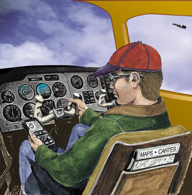
Is this the neatest toy or what?! Navigation is a piece of cake now!
The following account highlights the critical importance of maintaining proper map-reading skills and, more importantly, the need to always know your position on your visual flight rules (VFR) map even though you are flying a global positioning system (GPS) direct route.
A pilot and two passengers flew to Lac Portneuf, Quebec, in a float-equipped Cessna A185F on June 9, 1997, for a fishing trip and had planned to return home to Pittsfield, Maine, on June 13, 1997. The aircraft took off as scheduled on June 13 with a planned refuelling stop at Lac-Sébastien, 51 NM to the southwest; however, the pilot returned to Lac Portneuf because fog and low visibility prevented him from reaching his destination. The pilot delayed the departure until the next day. On June 14, the takeoff was delayed again because of fog and rain, but the pilot and his passengers eventually departed at 08:45 from Lac Portneuf on a VFR flight to Lac-Sébastien.
Around 09:30, witnesses about three miles west of Lac-Morin heard the sound of an aircraft engine pass overhead, soon followed by a sound of impact. They did not see the aircraft because the visibility was restricted by thick fog. The aircraft did not arrive at its destination as scheduled on the flight plan, and searches were undertaken. It was found at about 13:30 on the same day. It crashed at the 2500-ft. level of the east side of a mountain that rises to 2650 ft. above sea level (ASL) in straight-and-level flight on a magnetic heading of 250°. The aircraft was destroyed and the three occupants were killed. This synopsis is based on Transportation Safety Board of Canada (TSB) Final Report A97Q0118.
The pilot and both passengers were wearing seat belts but these gave way under the force of the impact, and the three occupants were thrown from the aircraft. The pilot was certified and qualified to fly day VFR only. The TSB determined that the installation of the floats was not documented in the aircraft's technical log books, as required by regulation. The aircraft was properly equipped for instrument flying. Further, it was fitted with an autopilot that kept the wings level and with a GPS navigation receiver. This navigation system is more efficient than traditional means of navigation and therefore reduces the pilot's workload.
The GPS installed in this aircraft displays the aircraft's geographical position, ground speed, time of arrival, distance, and track to programmed locations; it does not display ground elevation. The GPS receiver in the aircraft would indicate the bearing and distance to the destination at all times no matter where on earth the aircraft was physically located. Pilots tend to rely on this information and do not have to attend to where the aircraft is geographically located because they know they are not lost and they can always fly directly to their destination. The aircraft had no radio altimeter or ground proximity warning system, nor was either required by regulation.
An emergency locator transmitter (ELT) was installed and in working order, but the signal was not received by any aircraft or the Search and Rescue Satellite Aided Tracking (SARSAT) system because the antenna broke off on impact. About 08:00 on the day of the accident, the pilot observed a commercial aircraft flying southwest, so he telephoned a Lac-Sébastien aircraft operator to obtain current meteorological information at his destination. He was informed that conditions were favourable for visual flight, and that the ceiling was 2000 ft. ASL. At 08:20, the pilot submitted a VFR flight plan and he was to leave Lac Portneuf at 08:45 and proceed direct to Lac-Sébastien at an altitude of 2500 ft. ASL. According to the flight plan, the flight time was 45 min, with an endurance of 2 hrs. The chosen route was over a heavily wooded area with lakes, mountains and valleys; the elevation of the summits ranged between 2000 and 2900 ft. ASL. The pilot did not request or receive any weather information relating to the planned route from the FSS.
Conditions at Lac Portneuf were favourable for VFR flight on takeoff. In the area where the accident occurred, visibility was very restricted or almost zero in fog. At the time of the crash, a bush pilot who knew the area well reported that the peaks of the mountains were concealed by clouds. Four hours after the accident, the pilot of the search and rescue (SAR) helicopter observed localized low clouds in the area of the accident.
The east side of the mountain where the aircraft crashed has a steep slope and is densely wooded. The seaplane hit the ground, and then a rock face, in a slightly nose-up attitude with 5° of left bank. The wings broke off at impact and the cabin was heavily damaged. Examination of the engine and the propeller at the site suggest that the engine was turning on impact; however, the examination could not determine the power that it was producing. There was no evidence suggesting that the aircraft had suffered a structural failure, flight control problems, electrical problems, power loss, or that fire broke out during flight.
A controlled flight into terrain (CFIT) accident is when an airworthy aircraft inadvertently strikes the terrain or water without the crew's suspecting the tragedy is about to happen. According to CFIT accident statistics collected by the TSB, pilots often tried to see the ground to fly VFR even though the flight was taking place in clouds, at night, in whiteout, or in other conditions that did not permit visual flight. More than half of such CFIT accidents occurred in VFR flight. In 1995, the TSB recommended that Transport Canada (TC) initiate a national safety awareness program addressing the operational limitations and safe use of GPS in remote operations. TC issued several special aviation notices since, which detailed the use of GPS in Canadian airspace, and also published a number of articles on GPS in recent issues of the Aviation Safety Letter.
Analysis - The prevailing weather conditions at the points of departure and arrival were favourable for visual flight, but the pilot could not have known that local conditions along the way were poor, as the area is largely uninhabited and weather information was not available. Faced with deteriorating weather conditions, which made continuation of the flight hazardous, the pilot had to make a decision either to find a suitable lake for landing or to make a diversion. The pilot decided not to land, but to deviate from the direct route and try to reach his destination by veering southeast in order to fly in visual meteorological conditions (VMC).
It is likely that the pilot was not aware of his true position in relation to the terrain and topography of the area and was relying on the GPS to get to his destination because the weather conditions required him to focus the greatest part of his attention on manoeuvring the aircraft to maintain VMC. In low-altitude flight, the pilot would have difficulty following his progress on the VFR navigation chart, on which the elevation of the terrain appeared. Consequently, although the pilot knew where Lac-Sébastien was located in relation to his aircraft, he did not know his exact position and was flying at an altitude lower than some of the surrounding terrain.
The TSB could not determine why the pilot decided to continue the flight in adverse conditions, but it is likely that the nearness of the destination and the pilot's reliance on the GPS had an influence on his decision. The desire of the pilot and the passengers to return home after the first delay may have influenced the pilot's decision to undertake the flight.
In the end, the TSB determined that the pilot continued his flight in adverse weather conditions and probably did not have the necessary visual references to avoid hitting the steep slope of the mountain. Likely contributing to this occurrence was the pilot's reliance on GPS instead of the navigation chart while attempting to maintain VMC.
Flying Safely with GPS
by Ross Bowie, SatNav Program Manager, NAV CANADA
Most pilots who have used global positioning systems (GPS) agree that it makes flying more efficient and in some ways safer. Previous Aviation Safety Letter articles highlighted some potential hazards of misusing GPS. Many more pilots have started using GPS since the last article, so we thought it timely to review some of the safety issues.
Our experience with various types of GPS avionics suggests good training is essential. A couple of decades ago when the flight management system (FMS) appeared in new airliners, many pilots found that mastering the FMS was more difficult than flying the aircraft. Thanks to modern computers, today’s small GPS receivers have more features than FMSs, and the GPS manual can be thicker than the aircraft's.
Safety depends on using avionics properly. The easy way to learn is to focus on necessary functions: entering and activating a flight plan; making changes to the flight plan in the air, including adding arrival and approach procedures; and navigating en route, in the terminal area and on approach. Find out the best ways to do these things then practice. Many GPS avionics can be used at home or in the classroom. Take advantage of this to learn the basics without wasting fuel, and without having to watch for traffic and fly the aircraft.
Many pilots use GPS as an aid to visual flight rules (VFR) navigation. The key word is "aid," because VFR means seeing the terrain well enough to confirm your position on a map. Avionics used for VFR do not check for errors in satellite signals, so your GPS position could be bad. Finger trouble (entering the wrong waypoint co-ordinates) could have you flying very accurately to the wrong place. A "simple" panel mount or hand held unit depends on hundreds of thousands of lines of software code. When was the last time you made it through a week without your personal computer doing something that made no sense? None of these problems occurs very often, but neither does fuel contamination, and we check for that every day.
GPS accuracy and reliability have led some pilots to depart VFR on days when the visibility is too low for VFR navigation. This could lead to loss of control owing to disorientation or collision with unseen obstacles. When the weather is marginal, a VFR-rated pilot should assume GPS is not available then decide whether to depart. On days when the weather deteriorates en route, it is critical to use your map and fly at a safe altitude.
In instrument flight rules (IFR) flight a key to safety is situational awareness - knowing where you are, where you are headed next and how you are going get there without tangling with obstacles, weather or any other hazard. Keep up with the aircraft and the environment. Know your route, particularly in the terminal area, by preparing before departure and arrival. Time spent studying charts can make all the difference if air traffic control (ATC) changes your clearance; familiarity with terrain and obstacles can ensure awareness of hazards. Verify waypoint co-ordinates, or check that bearings and distances make sense; data bases are far from perfect. Know what the vionics should be doing next and ensure it does what you intended. If it does not, take control immediately, ensure the aircraft follows a safe path, then sort out the problem. Do not become engrossed with the avionics at the expense of flying the aircraft.
The complexity of GPS avionics can increase workload at critical times. With very high frequency omnidirectional range (VOR) stations, all we do is change a frequency and set a course. Time spent programming GPS avionics takes away from managing the flight, but there are ways to reduce the hazard. Complete familiarity with the avionics helps. The key, however, is to minimize programming during departure and arrival, when workload is already high and when the terrain is nearby. At the pre-flight stage, load the flight plan to destination and perhaps from destination to alternate to minimize head-down time and workload during flight. Most airlines discourage any programming of the FMS below 10 000 ft. on arrival. This would obviously not be practical in a Cessna 172, but the message is: get the programming done early and do not try to make major changes near the ground. Your number one job is to fly the aircraft.
One challenge we face with GPS is that the first generation of avionics does not have a common pilot interface. Transport Canada and NAV CANADA strongly support the use of moving map displays to enhance situational awareness. The good news is that the next generation of receivers all seem to have moving maps. Some units are simpler to use than others. It makes sense to evaluate a unit’s user-friendliness before buying.
Next, a controversial issue: if two aircraft on opposite courses are using GPS, does the risk of collision increase? The International Civil Aviation Organization (ICAO), Transport Canada and NAV CANADA, among others, have been studying this for several years and have not come to a conclusion. We rely on various procedures and services to avoid collisions: flying at an altitude appropriate to direction of flight; ATC, using radar and position reports; communications (on the proper frequency or frequencies) with other pilots in uncontrolled airspace and near airports without control or advisory service; and watching for other traffic. Some have suggested flying offset tracks. For IFR operations, ATC separation provides the necessary margin of safety. For VFR, the question is: offset from what? All we can suggest at this point is that pilots using GPS on regular VFR routes could stay to the right of centre. This is already recommended when flying along rivers or valleys. This does not replace communicating, watching for other traffic and minimizing head-down time.
Finally, ensure you are familiar with Canadian regulations. Much of the information on GPS comes from the United States, where pilots can use GPS in lieu of distance measuring equipment (DME) and automatic direction finders (ADF), and can fly overlay approaches without monitoring underlying aids. This is not currently the case in Canada for several reasons: we depend much more on non-directional beacons (NDB) and we do not have the density of VORs, airports or radar coverage. If your aircraft is not equipped for Canadian operations, you will encounter flight restrictions that may cause safety problems.
Transport Canada and NAV CANADA have set up a joint team to review GPS operational, technical and safety issues. If you have any comments on any aspect of GPS operations, please e-mail them to This email address is being protected from spambots. You need JavaScript enabled to view it., or send a fax to NAV CANADA’s SatNav Program Office at (613) 563-5602.
Updating Your Global Positioning System?
The following was taken from a daily occurrence report:
In IFR conditions, a Saab 340 with 20 people on board was cleared for the approach into an MF [mandatory frequency] aerodrome. It was on short final when the FSS staff observed a Robinson RH22 inbound near the approach path to the runway.
The helo was not in radio contact with FSS and was not monitoring the MF. The Saab pilot was able to land safely and saw the helicopter on short final.
FSS staff approached the pilot of the helicopter after it landed and the pilot said [that] he had been communicating on 118.0 [MHz] (that frequency had been decommissioned [three] years previously). He said [that] this frequency was provided by his GPS equipment, but, on [being] questioned, admitted that the GPS database had not been updated for "a couple of years." He did not consult his copy of the [Canada] Flight Supplement, which was on the seat beside him, because he was "too busy." When FSS staff asked for his name, the pilot declined to give it, and said [that] "[he hoped] nothing would come of this.
Upon departure, the pilot did not file a flight plan; rather, he flew on a company flight note.
Weather at the time of the incident was 700 ft. broken [and] 2000 ft. overcast, [with] visibility 5 mi. in light rain and fog.
Communicating on the right frequency in an MF is mandatory, but it should also be too easy. Having an up-to-date Canada Flight Supplement and looking at it or getting your GPS database updated regularly may cost a few dollars, but a mid-air collision could ruin the day for a lot of people.
Originally Published: ASL 4/1997
Original Article: Updating Your Global Positioning System?
Through the Mountains
He departed the Calgary area late in the afternoon on a VFR flight to the West Coast. However, the planned six-hour flight ended tragically less than an hour later when he mistakenly followed the wrong fork in the river and turned into a narrow box canyon.
Surrounded by 9000-ft. mountains, he could neither outclimb the terrain nor turn around. As he strained for altitude, the classic stall/spin occurred, with no altitude or room to recover. Neither he nor his passenger survived.
Weather did not bring about this accident, as it was a clear and sunny afternoon with light winds; nor was a lack of mountain-flying experience to blame, as the Cessna 150 pilot had flown the routes in the Rocky Mountains on numerous occasions.
Three factors may have led to the accident: vision, available charts and altitude.
First, the pilot was classified as having monocular vision (one good eye), and he was looking directly into the afternoon sun. Depth perception and map reading would have been difficult even without his visual handicap.
Second, the only map of the accident area recovered from the crash site was a 1:1,000,000 scale chart. World Aeronautical Charts show little detail of the valleys and passes in the mountains, and so it would have been easy to mistake the turn along the south branch of the river for that of the main river 3 mi. farther on.
Third, the pilot had flight-planned an altitude of 9000 ft., but evidently had not climbed to that altitude: the accident site was at the 6300-ft. level.
Originally Published: ASL 4/1997
Original Article: Through the Mountains


Pilot Resources
Ask ATS
Weather
TSB
Interactive Materials
NOTAMs
Air Safety Institute
ELTs
Aviation Safety Letter
SmartPilot proudly works with.


We would like to acknowledge the financial support of the Government of Canada for this initiative through the Search and Rescue New Initiative Fund (SAR NIF).