![]()


by Pat Very
En Route
There are countless combinations of routes throughout the mountains and picking the right one for you, your aircraft and your load comes with practice. The best way to learn about mountain flying is to fly in the mountains. With every flight, you will become more comfortable and knowledgeable.
Always monitor 126.7 MHz en route and request station updates when within range of an FSS. The radio operators are real professionals and are the backbone of the system. Try to confine your requests to the last 50 min. of the hour; the operators will be forever grateful for the time to get the hourly observations out on the computer for the rest of us.
Generally speaking, I like to travel as high as possible, consistent with comfort, and regularly fly at 10,000 to 12,000 ft. when crossing the rocks in VFR flight. Altitude has a number of advantages. Quite often, flying at 10,000 to 12,000 ft. will put you above scattered to broken cumulus and towering cumulus and, therefore, give you a smoother ride, lessening fatigue from turbulence. Altitude also will give you better radio reception for amendments and updates, as well as a larger spectrum from which to navigate. Then, of course, there is the old engine-failure scenario! Wouldn’t it be nice to be high if that ever happened, especially in the mountains? With the advent of LORAN and GPS, it's easy to set out blindly across the rocks, oblivious to the consequences. Knowing where you are at all times and how far it is to the nearest airport, settlement or road is a must.
Approach pass summits and ridges in level flight. The clearance required will be determined by the wind direction, velocity and cloud base. Again, look for clues — ridge plumes, cumulus, bear paws, bending trees, wind on the water, and so on — and check your vertical speed indicator and altimeter. Under no circumstances should you still be climbing for this clearance altitude when arriving at the summit or ridge. If you have to turn around, make your decision early while there is still plenty of room. By the way, don't even think about penetrating cloud; it's the quickest way that I know of to become a statistic.
Watch out for the shadowed valley sides in the late afternoon: under certain conditions, they can all but disappear, leaving you with a dangerous guessing game. If you feel uncomfortable and conditions allow, climb for better reference.
On the bright side, generally speaking and owing to prominent landmarks, map reading tends to be easier in the mountains than on flat land.
For those of you with really light aircraft such as Cubs, Champs, and ultralights, a lift bonus can occasionally be reaped by flying the sunny or downwind side of the valley. Recently, while ferrying a J-3 Cub (without mixture control) through Banff, Alberta, back to Chilliwack, British Columbia, I found myself, owing to a variety of conditions, unable to climb to a safe altitude to clear the pass. After a few unsuccessful attempts, I spied a bright patch of sunshine on a west-facing slope. By positioning my aircraft over the sunny slope, I was able to climb to a sufficient altitude to clear the pass with a degree of comfort and safety.
Dominated by the Pacific with its many currents and weather patterns, the British Columbia coast presents unique challenges to the pilot. It is home to some of the fastest-moving weather on the continent. Conditions can change for the worse with very little warning. With its many channels, straits and fjords, the coast can be transformed by low ceilings into a series of tunnels, many of which have absolutely no flat ground before meeting the sea.
The lower the ceiling, the more the busy traffic is compressed into a smaller area. Under these conditions, be sure to have all lights on, keep a sharp lookout and try to stay to the right. Monitor local stations and transmit your position as you transit the area. Also, be aware of the new CARs requirements for VFR flight in uncontrolled airspace. Operating at or above 1000 ft. AGL requires the following:
- during the day, 1 mi. flight visibility;
- at night, 3 mi. flight visibility; and
- 500 ft. vertically and 2000 ft. horizontally clear of cloud.
Operating below 1000 ft. requires:
- during the day, 2 mi. flight visibility;
- at night, 3 mi. flight visibility; and
- flight clear of cloud.
Be sure to update your weather at every opportunity.
One fall afternoon at my Savary Island cabin just off Powell River on the British Columbia coast, I was standing on the deck listening as the familiar drone of a Beaver approaching the island got louder and louder. The weather was terrible. Low stratus capped the trees and I strained my eyes through the drizzle and fog to catch a glimpse of the aircraft as it passed. My cabin is located about 100 ft. above the sea and 100 yd. inland. As the sound reached its loudest point, I noticed a tail strobe just above the cliff. The rest of the aircraft was below and not visible. I remember thinking to myself at the time, "Better you than me, pal," but, on the coast, life goes on and, most of the time, so does the flying. Sometimes the weather cooperates and it's a pilot’s delight; other times you wish you were home by the fire with a good book. Be cautious on the coast and ask lots of questions.
Mountain Strips
Mountain strips come in a myriad of sizes and shapes, each with its own idiosyncrasies. Some are one-way, meaning that you land one way and, usually because of terrain, take off in the opposite direction. With many one-way strips, you are committed once on short final. Overshooting would be out of the question because of the climb gradient required to clear terrain. Some are not strips at all, but rather straight stretches of logging roads used by logging companies. You may choose not to land on strips such as these, but keeping a mental picture of their position might come in handy in the event of an emergency. Airports range in height from sea level to as high as 9000 or 10,000 ft. Knowing how to calculate density altitude and how it relates to your aircraft's performance is imperative.
While stationed in Colorado Springs, Colorado, with the military, I had occasion to visit a small town in the mountains called Leadville. It boasts the highest airport on the North American continent at 9969 ft. The density altitude in the summer can reach 13,000 ft. I drove to the airport, more out of curiosity than anything, and spoke with a young instructor working at the flight school. She was teaching in a Cessna 172. When I asked her how she could constantly operate that close to the service ceiling of the aircraft, she replied, "Seems normal to me — I learned to fly here. It's all a state of mind. Besides, everything's downhill from here anyway." I guess the lesson here is that the more familiar you become with something, no matter how unusual, the more comfortable and proficient you become.
Many airstrips, such as those in Pemberton, British Columbia, and Banff, are at the junction of two or more converging valleys. Because each valley can generate its own weather and, therefore, its own wind, it's not unusual to see wind socks at either end blowing in opposite directions. Use extreme caution when operating in windy conditions from these types of strips.
Watch out for strips beneath glaciers and ice fields in the late afternoon. Subsiding cool air known as katabatic wind can cause considerable downdrafts and seriously diminish your aircraft's performance.
A word to the wise: avoid static run-ups on gravel and sand. By holding the controls back and learning to perform run-up and pre-takeoff checks while backtracking, you will save many dollars in propeller repairs. Be ready to go when you reach the end; by stopping, you can lengthen your takeoff roll by as much as 200 ft.
Mountain flying is a rewarding experience. Plan ahead, stay alert to the changing conditions, and enjoy the splendour below. Happy landings!
About the Author
Pat Very is a private pilot with a commercial licence. He started flying in 1970 on the East Coast, but since moving out West in 1978, he has accumulated over 4000 hrs of experience in and around the Rocky Mountains.
Originally Published: ASL 1/1998
Original Article: Mountain Flying - Part II
From Issue 1/92
Company Aviation Safety Management
Immediately after an aircraft crashes, accident investigators launch into a concentrated search for cause factors. Their sole objective is to identify the cause and communicate it to the aviation industry in an attempt to reduce the chances of a repeat performance by another operator. Fortunately, many aircraft operators benefit from this approach to accident prevention, but, regrettably, someone always has to have paid the supreme price. You cannot just rely on learning from the mistakes of others ¾ it's too much of a sacrifice for them!
In the majority of cases, accidents happen as a result of an unbroken chain of events that ultimately results in total system failure, but these events that form the chain can be controlled. As soon as the sequence of events is positively altered, the chain is broken and the accident prevented and reported as an incident with accident potential.
Breaking the chain is a challenge that all aircraft operators are confronted with. Some do it systematically and very effectively. Others do it by trial and error. The latter method very often costs lives and money in large amounts.
We believe that successful operators function efficiently and safety because of their Company Aviation Safety Management Program. With an effective program in place, accident chains rarely form. And in cases where they do begin to form, they are broken after the second or third link.
It does not matter how large or small an operation is. It could be one single-engined aircraft or a complex fleet of wide-bodied jet transports. The principles of aviation safety management are applicable to either and all of those in between.
Responsibility for safety always has to start at the top and work down through the various levels of management to the bottom rung.
Safety management requires professionalism, integrity and two-way communication. With effective communication and responsible attitudes, safety deficiencies are identified, reported and eliminated. To identify deficiencies, which are actually links of the accident chain, most operators require a dedicated safety officer to act as an advisor to the chief executive officer, a safety committee and a reporting mechanism so that all employees can assist in the identification of system flaws.
In the case of a one-person operation, the individual has to wear all the hats but still apply the basic principles of monitoring, identifying and acting to eliminate system deficiencies and reduce the accident potential.
We believe that our accident-prevention program offers a solution for establishing effective safety management.
The Directorate of System Safety staff in all of our regions provides guidance, courses and workshops on Company Aviation Safety Management to the Canadian aviation industry without cost.
If you do not have a safety program tailored to your needs, call on your Regional Aviation Safety Officer for assistance. Click here to view the list of regional offices.
Try it — you might like it!
Originally Published: ASL 1/1998
Original Article: From Issue 1/92 - Company Aviation Safety Management
From Issue 6/87

Pilot Decision Making and Safety
If you've decided to actively participate in the Pilot Decision Making workshops now being conducted by your Regional Aviation Safety Officer, you've already made a significant personal contribution towards the promotion of aviation safety in Canada. We hope that you'll attend and share your concerns at all of the PDM safety sessions being offered in your area.
If you're undecided about participating, contact your RASO and ask for more information about decision-making training and what it can do for you.
The program is very dependent on your participation. By sharing some of your thoughts and concerns, others will benefit from your experiences. Of course, you'll gain too by listening and analysing the thoughts and concerns of other pilots.
The workshops being presented across the country by aviation safety specialists were developed by an international group of experienced pilots and aviation psychologists. Although decision-making concepts might appear to be complex, the workshop materials are presented in language that pilots understand.
You'll benefit by discussing successful flight scenarios resulting from correct decisions as well as learn from the fatal mistakes of others that resulted from either wrong or no decisions. The sessions will help you identify risk, stress and negative attitudes and teach judgment and decision-making concepts. Some of the concepts may be new to you. If not, hearing them again will jog your memory. We recommend that you give Pilot Decision Making a shot. Who knows — the life you save may be your own.
You wake up in the morning, your brain clicks on and you have to start making decisions. Do you work? Do you play? What do you wear? What do you eat? If you're a flyer, you'll be deciding from preflight to post-flight. Are you prepared for it? Are you rested? Are you current? Can you handle it? Do you have a system to exercise sound judgment to assist you in completing a flight safely and efficiently?
Canadian aviation accident stats continue to reveal that too high a percentage of cause factors relate to judgment and decision making.
The following examples from a recent stack of Canadian Aviation Safety Board Aviation Occurrence Reports support that finding.
A Cessna A188B pilot decided to attempt a takeoff from a 16 ft.-wide dirt road. With ditches on either side, there was no margin for error. He lost directional control and ran the aircraft into the ditch on the left side, causing substantial damage.
The first poor decision was landing there. The second and costly one was attempting to take off.
A Piper PA31-310 Navajo pilot attempted a cargo flight with three scheduled delivery stops. During the deliveries, the aircraft wasn't refuelled or even shut down at the last two stops. Enroute after the last delivery, both engines stopped. The aircraft was landed wheels up in a ploughed f ield. Damage was extensive.
The pilot admitted that he didn't compute fuel requirements and stated that he was anxious to get home because his wife was ill in the hospital.
Being preoccupied and stressed can have a disastrous effect on decision-making processes.
Although the pilot of a Lake LA4-200 was not instrument rated and most of his recent flying had been day VFR flights, he decided to depart from a remote site in marginal weather at night. Shortly after takeoff, the aircraft impacted the ice of a lake at high speed. The pilot and passenger were killed. The decision for the night departure in snow showers was the wrong one for the day VFR operator.
After starting the Piper PA-28-140, the pilot went to lunch and left the aircraft engine idling for 20 min. After lunch, he noticed that the aircraft was covered with hoarfrost. He removed some from the wing-root areas, but left the outer wings as they were. After a longer-than-normal takeoff roll, the aircraft became airborne but wouldn't climb. The pilot attempted to turn to avoid some trees, but the left wing struck a tree. Damage was substantial.
Two factors contributed to this accident, and both involved decision making. Wings covered with hoarfrost won't fly. Engines with fouled plugs caused by excessive idling won't produce rated power.
We can learn from the mistakes of others, but it also helps when we upgrade or refresh our judgment skills. Whether you are a veteran flyer or a rookie, we recommend attendance at the Pilot Decision Making seminars that are being offered by your Regional Aviation Safety Officers.
Originally Published: ASL 1/1998
Original Article: From Issue 6/87 - Pilot Decision Making and Safety
From Issue 7/82
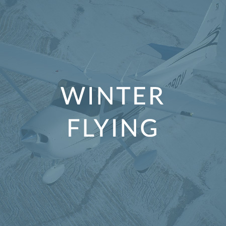
Snow, Slush and Drifts
Comes the "season to be jolly" — not to mention extra vigilant during takeoff, landing and ground operations. Here are a few brief examples of problems some pilots encountered last winter. Perhaps their experiences will help keep you out of trouble.
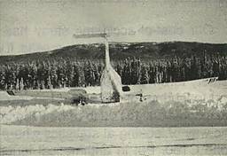
— The experienced PA23 pilot lined up with the centre of the runway on approach — at least he thought that he did. The snow-covered unmarked runway was difficult to distinguish from the surrounding terrain and he landed beside it. The right wing struck a snowbank at high speed and the aircraft pivoted 180° and ended up well bent (photo).
— Enroute, a low-time 172 driver decided to land to make a phone call. The airfield he picked was only semi-snow-cleared, and so he attempted a short-field landing with an 8-kt. tailwind. He didn't make it. On the roll-out the aircraft swung to the left, and right rudder didn't stop it. When the left wheel contacted snow at the edge of the runway, it dragged the aircraft around further. It slid sideways 400 ft. through deep snow, damaging the mainframe and lower cowling. Then he had a few more telephone calls to make.
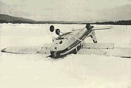
— Another 172 pilot got too low on final in strong gusty winds. The mainwheels touched a snowbank just short of the threshold and the aircraft flipped onto its back (photo). He hadn't made enough allowance for the gusts and hadn't seen the snowbank.
— A 150 student was practising solo for his night rating. On landing, the aircraft bounced. With the nose high, he lost track of the runway. The aircraft drifted left and, when it touched down again, the left wheel was in snow. This dragged it into a snowbank, where it nosed over inverted. Diversion of attention, even briefly, can lead to trouble.
— A Bellanca pilot was done in by a patch of slush. After the landing, the left wheel hit the patch and the machine was dragged into a snowbank and badly damaged.
— A PA28 pilot was practising "off airport procedures". The trouble was that the wind was outside the maximum crosswind limits on the runway that he elected to use. It was more favourable on other runways. He used 25° of flap on approach and landing, then brought them up shortly afler touchdown. As the aircraft decelerated, it weathercocked into the snowbank along the side of the runway. Ignoring the "book" resulted in an unexpected "off airport" landing, a bent propeller, a damaged nose gear, a crumbled wing, and probably a sadder but wiser pilot.
— The pilot of a ski-equipped 185 purposely planned to take off close to the edge of a snow-covered taxiway with center bare patches. Unfortunately, he was a little slow correcting for gyroscopic effect as he poured on the power. The aircraft swung. The left ski hit a snowbank and that was the end of the trip. The manoeuvering safety margin had been cut too fine for recovery after a mistake.
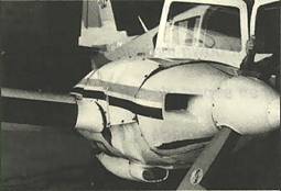
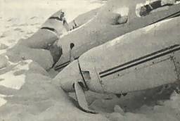
— An experienced senior commercial pilot with an instrument rating had difficulty seeing where he was going on takeoff. It had been snowing all day and the runway was covered with two inches of fresh snow. Vis was down to less than a mile. Melting snow on the heated windshield added to his visibility problem, even though he got out of the aircrafl just before takeoff to wipe it off. The runway lights were partially obscured by snow and he had trouble making out the edges of the runway. He lined up with what he thought was the center and applied takeoff power. The aircraft went straight as an arrow at a slight angle before it ran off the runway some 600 ft. along (photo). The nosegear collapsed as it plowed through a snowbank.
Two propellers were bent and the nose split open (photo). The provincial government operating the airport is evaluating a more suitable type of day/night/all-year runway markers.
A few reminders of winter hazards from other pilots' experiences. We don't want to write about you next year.
Originally Published: ASL 1/1998
Original Article: From Issue 7/82 - Snow, Slush and Drifts


Pilot Resources
Ask ATS
Weather
TSB
Interactive Materials
NOTAMs
Air Safety Institute
ELTs
Aviation Safety Letter
SmartPilot proudly works with.


We would like to acknowledge the financial support of the Government of Canada for this initiative through the Search and Rescue New Initiative Fund (SAR NIF).