![]()


Twice Lost, Twice "Fuelish", Twice Saved by Alert Flight Service Specialists
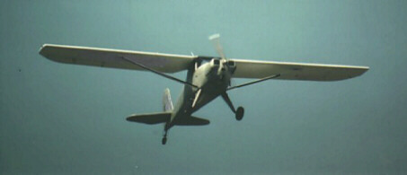
Luscombe in flight.
The solo Luscombe SL-8 pilot was en route VFR from Fort Nelson, British Columbia, to Watson Lake, Yukon Territory. Its barely more than 100 NM as the crow flies, and slightly longer if youre flying IFR ("I Follow the Road"). When the pilot became uncertain of his position (read "lost"), he called the Whitehorse FSS through the Watson Lake remote communications outlet. The alert specialist who took the call advised the pilot to climb and attempt to locate the highway.
Following the advice, the pilot located his position over the highway; unfortunately, at about the same time, he ran out of gas. The engine quit, and he made a successful forced landing on the Alaska Highway. Co-operative RCMP officers arranged for fuel and blocked the highway, allowing the intrepid pilot to depart again to continue to Whitehorse.
Several days later, it was the same aircraft, the same pilot and the same story. This time, the Luscombe pilot was flying from Atlin, British Columbia, to Juneau, Alaska another 100 NM trip if you take the direct route, but longer if youre flying IFR (here, this means "I Follow the River").
This time, the Whitehorse flight service specialist overheard a United Parcel Service courier flight attempting to assist the Luscombe pilot, who, having flown past his intended destination, was lost somewhere south of Juneau and had only 30 min. of fuel remaining.
The specialist suggested that the pilot activate his ELT. Then he alerted the Victoria Rescue Coordination Centre, the Juneau FSS and the United States Coast Guard to the serious situation. With the aid of the ELT, the Coast Guard helicopter quickly located the crash site and the pilot, who was waving from the shoreline.
Fly IFR in the northern mountains (thats "I Follow Roads/Rivers"), have good maps, be meticulous in your map reading (a GPS wouldnt hurt), carry full fuel and, above all, listen to and bless those flight service specialists.
Originally Published: ASL 3/1997
Original Article: Twice Lost, Twice "Fuelish", Twice Saved by Alert Flight Service Specialists
To the letter - Re: GPS Navigation and Collision?
Am I the only pilot who believes there should be less fear of collision using the Global Positioning System (GPS)? First, the TSB links GPS to the Sioux Lookout collision, and now I see that a Mr. J. Tom Lockhart wrote to you that he will fly 0.1 NM to the side of GPS direct routes because he too fears a collision using GPS.
Maybe I'm blind, but I have been flying direct routes under visual flight rules (VFR) with GPS for the last four years and have experienced no increase in close calls. For collisions to occur, aircraft must be flying between the same waypoints at the same altitude.
Instrument flight rules (IFR) operations are not a problem. Air traffic controllers separate IFR flights from each other, and IFR and VFR flights are at different altitudes (except in climb or descent). GPS can't cause collisions in these situations.
Even for VFR, I believe there is less chance of a collision using GPS. Unless the departure runway heading is close to the direct course to my destination, I take up a direct course to my destination at some point after takeoff. I do not often follow the direct line between my origin and destination. The point at which I take up my course is different on each flight, even to the same destination, given the different winds, temperatures, climb speeds and rates, area traffic, and so on.
It is only if you are flying directly between navigation aids, such as when you are flying an airway or route, that there is an increased chance of collision under VFR, and then only if both aircraft are flying in the same direction, at the same altitude.
Going GPS direct will usually preclude following identical routes. In fact, there are more routes if we all fly GPS direct than if we stick to airways. The chance that another plane is flying the same route as I am is lowered, not increased, by GPS. Sure, our paths will cross from time to time, but GPS has no influence on this.
With GPS, coordination via radio with other traffic and air traffic controllers is more precise because the pilot has current and accurate position, speed and track information. I feel confident that other traffic will find me if I can give my position accurately. I know it helps me if other pilots do the same.
The real issue is how effectively we use air traffic services, flight service stations, our eyes, our radios and our brains. I do not fear more accurate navigation!
Mike Shaw
Ottawa, Ontario
Originally Published: ASL 3/1997
Original Article: To the letter - Re: GPS Navigation and Collision?
To the letter - Re: Mountain Flying
I read with interest the article on the Hope-Princeton VFR route in Issue 2/97 of the Aviation Safety Letter. Flying VFR on this route is extremely dangerous unless the conditions are such that a direct flight between the two airports is possible. In fact, the route is to be avoided if there is any possibility of entering IFR conditions.
I am not a high-time pilot, but I have managed to acquire 1750 h, most of it in cross-country flying in Canada, the United States and Mexico. In 1981, after obtaining a private license plus a night endorsement, I received some excellent advice from experienced Penticton pilots: do not use the Hope-Princeton route in inclement weather. I understand that Hope now has automated weather reporting, which
compounds a bad situation.
I was advised to use one of the following routes in uncertain weather:
- Because the Fraser Canyon from Hope to Lytton turns almost 90° north at Hope, the moist systems that often affect the Hope-Princeton or Coquihalla Highway routes will not affect the canyon, and good legal VFR in the Canyon is possible. As Lytton is at an elevation of 922 ft. and Hope, at an elevation of 128 ft., there is no precipitous rise in the elevation enroute. Lytton to Merritt (or Kamloops, if necessary) is most often open if the Canyon is open at Hope.
- If one does fly east or west from the Canyon, an excellent route can be found at Boston Bar. Fly the power lines, as this is the lowest elevation.
W. Lawrie
Penticton, British Columbia
Originally Published: ASL 3/1997
Original Article: To the letter - Re: Mountain Flying
To the letter - Re: Pilot Decision Making
Every time I read the Aviation Safety Letter, I wonder, "What can we do to improve safety in aviation?" Sometimes, I cannot believe the stories, and I think about how simple it would be to avoid accidents.
I think we would do a lot better if we got rid of the "macho" attitude. I am a woman with a private licence. I have just over 100 h flight time, and I do not think that I am God just because I can fly an aircraft.
At an uncontrolled airport, I refused to obey one of my instructors when he wanted me to land over top of an aircraft that was holding on the runway for takeoff. Not having had any contact with the other pilot, I believed that the manoeuvre was too dangerous. Was my instructor testing me, or did he just want to get on the ground as soon as possible because his next student was waiting?
I rent aircraft from various flying clubs. I have often refused to fly planes that have worn-out tires or that produce unusual vibrations during the run-up. I inspect the aircraft before a flight and I am not afraid to consult with a more experienced pilot or the aircraft maintenance engineer when in doubt. I always brief my passengers and make sure that they know what to do and what not to do during regular flight or emergencies. If I feel that I will not be able to land the plane within a safe distance on the runway, I simply go around. I do not think about how I look as a pilot, but about how safe I am on the ground and in the air.
Some people think that I am going overboard about safety, and I have been laughed at many times, but so many simple precautions can be taken. I still do not understand why pilots with many hours under their belts would do so many "stupid" things, thinking that they and their passengers are immortal.
Thanks for the Aviation Safety Letter. I hope that this letter will make some pilots think a bit more.
France Bergeron
Saskatoon, Saskatchewan
Originally Published: ASL 3/1997
Original Article: To the letter - Re: Pilot Decision Making


Pilot Resources
Ask ATS
Weather
TSB
Interactive Materials
NOTAMs
Air Safety Institute
ELTs
Aviation Safety Letter
SmartPilot proudly works with.


We would like to acknowledge the financial support of the Government of Canada for this initiative through the Search and Rescue New Initiative Fund (SAR NIF).